")
")
")
")
                    |
| Clck per allargare |
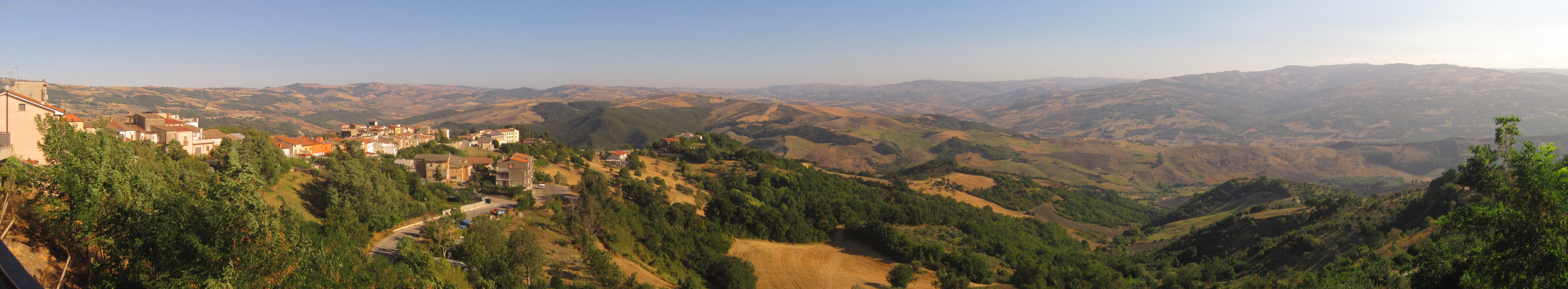
The day starts off well: breezy at last! From Pietracatella I go straight down towards the tratturo on practical cart tracks intersecting the asphalt road which, instead, keeps on zigzagging. Thanks to the elevation I can enjoy the beautiful landscape of the valley where the tratturo runs... or better... where the SS645 runs! I already know that I will inevitably have to get back to the road and I'm not at all keen on the idea.
When I reach the tratturo, I try to follow the path indicated on OpenStreetMap. A preliminary inspection of the satellite images I had made before leaving does not bode at all well. Indeed, the passage is blocked by lush vegetation once again. My attempt to get round the obstacle through the fields is unsuccessful. This is not the first time that the route indicated on OpenStreetMap has led to a dead end, but this time there seems to be no path at all: non-existent routes should not be marked!
Too bad..., I brace myself and start walking along the SS645 road. There are 2.5 km of asphalt lying waiting for me but, most of all, 2.5 km of intense, fast-moving traffic. The verge is wide enough to feel reasonably safe, but nevertheless it is not a pleasant situation.
After a distressing half hour I reach the "Bridge of the 13 arches", beyond lies Apulia: I already feel close to the finishing line! It is time to leave the valley of the Tappino creek, and begin exploring the valley of "La Catola" brook.
The route is still on a paved road, but there is basically no traffic and, after a short while, I can leave the main road for an abandoned side one. A few trees offer some respite from the sun.
And now the dreaded, arduous final climb looms over me: I knew it was there waiting for me. Once again I have to leave the tratturo for accommodation issues. I smile at the thought that in an area full of ancient (now tumbledown) taverns for transhumant shepherds, the only chance of finding accommodation is far away from the tratturo.
I have to cover a 400 m difference in altitude in barely two kilometers of... paved road. Fortunately, there is a light wind to relieve this deadly climb. The road is ruined by many landslides, the whole hill seems to be affected by the movement. I occasionally shoot some photos on my way up, and in doing so take advantage of these pauses to recover and get my breath back... or the other way round, hard to say. The landscape is so beautiful it makes up for such great strain.
The village of San Marco La Catola eventually appears. This has been the stage with the longest strecth of paved roads but it has actually been those 2.5km of traffic which spoiled the day. I do hope some public institution will set out to open up an alternative route along the Tappino creek. I could have actually had a longer walk to the village to avoid the tarmac road (see the box on the side here where the section "If I were to do it again" has reappeared). I hadn't realised when I had mapped out my route - oh well, next time perhaps!
After my usual afternoon rest, it is time for my ritual tour around the village and I press on for a visit to the Convent of the Friars Minor Capuchin.
In the evening, a waiter in the pizzeria where I am having my dinner suggests an alternative route for the stage I have planned for tomorrow. I had thought of going back down to the valley and following the tratturo up to Motta Montecorvino. The tratturo in this section should be in good condition. To do this I need to climb two hills. Instead, the waiter recommends a shorter stage at a higher altitude, through St. Christopher's wood, with minimal changes in elevation. But it would all be on asphalt roads, and I most certainly do not fancy this idea at all.
Later that night in my room I consider his suggestion. By looking carefully at the maps, I realize that the indication I have been given is correct and, more importantly, that there are alternatives to the asphalt route the waiter recommended. I am torn between following the path I had originally planned or allowing myself a relaxing stage which may hide uncertainties since I have not double-checked this new route with the satellite images. In the end I go for the second option, but I have the feeling I have betrayed an old friend.
 |
 |
Track of the day